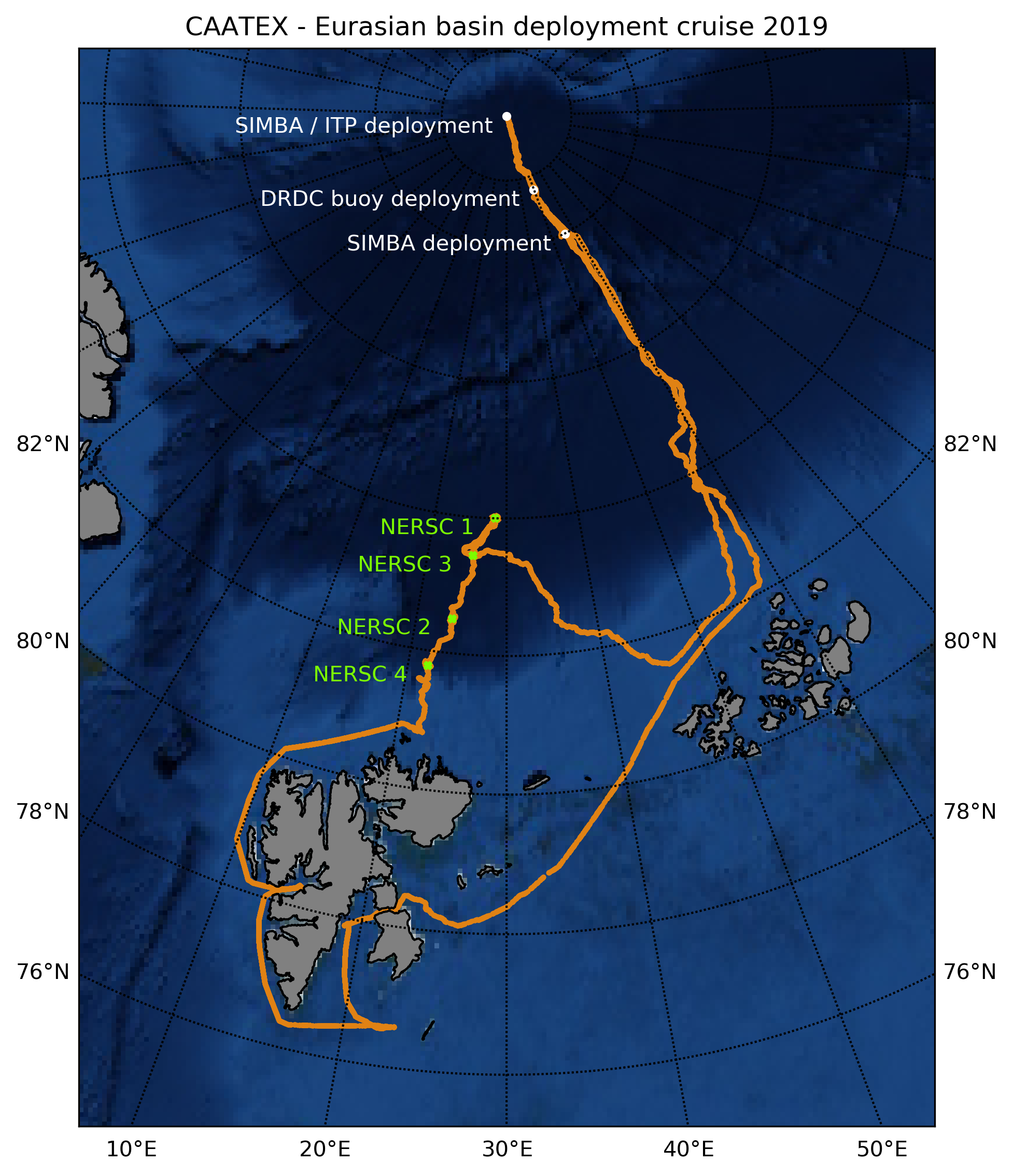
The Coordinated Arctic Acoustic Thermometry Experiment (CAATEX) research cruise was conducted with the Coast Guard vessel KV Svalbard in the Arctic Ocean from August 14 to September 9. Field experiments were conducted by Nansen Center in collaboration with eight other Norwegian and international research institutions. The main goal of the cruise was to deploy three acoustic rigs, four buoys, and an oceanographic rig. The rigs are deployed in the Nansen Basin and will collect data daily that contributes to new knowledge about how the temperature of the ocean under the polar sea ice cover will vary over the coming year. Several drifting ice buoys have been deployed and these with gather information about the ice and how it will grow and vary in thickness throughout the winter and again how it will melt during the coming summer season.
During the four-week CAATEX-2019 cruise four rigs were deployed in the Nansen basin north of Svalbard. Each rig is around 4000 m long and stands vertical in the water column by means of heavy anchor and buoyancy spheres. Three of the rigs are part of a larger international acoustic thermometry network that measures mean ocean temperature across the entire Arctic Ocean from the areas north of Svalbard to the Beaufort Sea north of Alaska. The rigs are also equipped with oceanographic instruments for point measurements of salt and temperature, ocean currents, ice parameters and the pressure on the bottom. The CAATEX system is complemented by an oceanographic rig funded through the INTAROS: Integrated Arctic Observation System project. This rig includes similar instrumentation for measuring physical ocean parameters, but also instruments for measuring bio-geochemistry and passive measurement of sound in the ocean. Point measurements are important for process studies on a local scale in different parts of the Arctic. The measurement program is designed to provide necessary and unique data that will help to increase the knowledge of the properties of the water masses under the Arctic sea ice and their variations over one year. When the four rigs are taken up again in 2020, they will have unique and complementary measurements that can be used together with data from other oceanographic rigs and buoys in other parts of the Arctic Ocean.
A key question is how has the temperature and processes in the ocean under the sea ice changed over the last decades? This knowledge is essential to know how the extent and thickness of the sea ice is also affected by changes in the temperature and processes in the water masses below the sea ice. Similar transarctic temperature measurements were last collected in the nineties and the CAATEX measurements will therefore be able to provide unique information about possible temperature changes in the water masses under the sea ice over the last 20 years. The deployment of the rigs was challenging due to varying ice drift conditions and that the bottom topography in large parts of the Arctic Ocean is not adequately mapped and known. Therefore, before deploying each rig, the bottom topography must be measured and mapped in an area with a radius of more than 30 kilometers around the selected position. This mapping was challenging in tight pack ice. Furthermore, variation in ice drift must be carefully monitored before and during the 7-9 hours it takes to put the rig to a depth of 4000 meters. With the careful planning, previous experience, good information about the weather and ice conditions on site and a skilled crew, all four rigs were successfully deployed. One rig was picked up which was deployed in 2018 as part of the INTAROS project.
During the KV Svalbard cruise, four ice-ocean buoys were placed on the sea ice. All buoys now drift with the ice from the North Pole towards the Fram Strait, while continuously collecting environmental information about the sea under the ice, about the nature of the sea ice and about the air near the ice. The data from these buoys can provide information on where and in what part of the year the ice melts most from the underside that is in contact with a warmer seawater or where and when it melts from the surface in contact with warmer air layers. Ice stations were conducted at nine locations with extensive observations of the characteristics of the sea ice, and seawater under the ice. At the ice stations, ice cores were drilled and taken to study the structure of ice in laboratories. Measurements of ocean currents and turbulence under the ice, measurements of light and algae, as well as passive measurements of sound were made. Larger areas around KV Svalbard were investigated using drones equipped with various remote sensing sensors to map sea ice and leads. Regular sea ice observations were conducted using the Arctic Shipborne Sea Ice Standardization Tool (ASSIST) developed by the International Arctic Research Center in Fairbanks. CAATEX complete measurements taken during the MOSAiC expedition measurements.